|

|
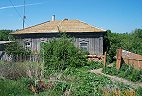
The Settlement of Alexandertal
This is situated on a large hill, on the right side of the Astrakhan postal highway, one versta (0.66 mile) from the river Ilavlia. The first settlers came from the village Sosnova, Balzer District, in 1853, and at first settled along the ravine toward the center of the communal land allotted to them. The settlers who arrived after them, however, did not like this spot and they, together with the first settlers, moved to a lower place along the postal highway and there dug out their huts.
The next spring, however, in 1854, the high water flooded their dugout huts and forced them to leave that place also to re-settle on higher ground, where the settlement has remained to the present. Since the settlers, with few exceptions, came from Sosnovka, the settlement is popularly called Novaia Sosnovka (New Sosnovka) by the Russians, and Neu-Schilling by the Germans, because their original home Sosnova was called Schilling by them.
Later the new settlement received the official name Alexandertal (Alexander's Valley), in memory of the blessed Emperor Alexander II (he was assassinated in 1881), God rest his soul! At the tenth census (taken in 1857-58) there were counted in this settlement 189 males and 171 females. At present there are 378 males and 350 females, most of whom are of the Lutheran faith. The settlement does not have a store or flour mill, but it does have an oil-mill. The allotted community land includes: farmyards, pasture and unproductive land, 1753 desiatinas; arable land, 2525 des.; meadows, 27 des.; forest 78 des.; total: productive land, 2606 des. and unproductive land 1777 des.
The school was established in 1854 in a community house and is supported by the settlers in the community. There are 47 boys and 47 girls in this school. In the summer a few men from the various settlements of Ilavlin county, after finishing their own farm work, go to the Don region and the Novouzensk and Tsarevsk districts to supplement their income by agricultural work, such as cutting hay and grain, threshing grain, constructing dams, etc.
Although this report says the village was established in 1853, its 1858 census lists 3 people who died in 1851 and 1 who died in 1852 so there may have been at least unofficial settlement at least as early as 1851. The report also says there were 360 residents as of the tenth, 1857-58, census. However, the translation I have of the 1858 census contains only 198 residents plus 11 who had died. I don't know whether the report translated above was incorrect, or whether the translation I have of the 1858 census is incomplete.
The Astrakrakan postal highway ran a few miles west of and parallel to the Volga River. On various maps the names of the neighboring German villages on this highway north to south are: Neu-Norka, Alexandertal, Rosenberg, and Unterdorf.
|
|